GENERAL INFO
WATER FLOW CONDITIONS
The US Geological Survey posts the current flow info for some 3,000 hydrologic stations around the country on their website: USGS Real-Time Water Data. In order to find Maryland-specific information (or any other state you are planning to visit!), you can just simply type "Maryland" in the search box in the map.
PHONE NUMBERS
There are several phone numbers that provide information that could be of some use to trout fishers. All involve releases/water conditions at some important streams.
Gunpowder 410-329-6821
Deep Cr. Lake 315-413-2823
N Br. & Savage 410-962-7687
The Gunpowder number is Backwater Angler next to the stream, run and operated by Theaux LeGardeur; either a person will answer or, after hours, the tape will tell what's going on the stream right then. The Deep Creek Lake power plant release is what flows into the Youghiogheny at Hoyes Run near McHenry; the clear water of the release usually adds 3-10 inches to the flow of the river. The Corps of Engineers tape (phone #3 above) for the North Branch and Savage is updated periodically, as flows change and upcoming events approach; also go to this link for expected releases: JR & Savage dams projected releases. Good wade fishing flows for the former are in the range of 150-250 cfs, the latter 75-110 cfs; dangerous/unwadeable flows are >350 cfs and >150 cfs, respectively. Best floating levels for fishers on the N. Branch from Barnum to Bloomington are about 250 - 400 cfs; below Westernport they are 300 - 500 cfs.
POACHERS
The chapter has some business-sized cards that carry the two toll-free phone numbers for reporting poachers in Maryland 24 hours a day. Be sure to pick up a card at the monthly meetings or your nearby tackle shop to carry in your wallet. Both numbers now ring in the same room for the MD DNR Natural resource Police. Remember, there may not be an immediate response to your call, but it is logged. Patrols are based in part upon reports of poaching activity in a given area. When the reports start accumulating, then more patrols and better response times might be expected. The DNR Police number is 800-635-6124 and the State Parks number is 800-825-7275. Try to get license plate number and description of the individual(s) involved.
PATUXENT WATER TEMPS
Until recently, the U.S. Geological Survey gauging station below Brighton Dam on the Patuxent did not have a river water temperature sensor and the USGS was unable to add one because of funding restrictions. Recognizing the value of such information for this upcoming fishery, members of PPCTU approached the Maryland Department of Natural Resources and asked if we could assist in the provision of this service. The Trout Unlimited Mid-Atlantic Council (MAC) agreed to share the cost of the addition.
SAVAGE RIVER
Trout Unlimited has listed the Savage River in Western Maryland as one of 10 Special Places. For more details, go to https://www.tu.org/press-releases/savage-river-watershed-one-of-10-special-places/.
MARYLAND DNR ANGLER ACCESS MAP
Maryland Dept. of Natural Resources hosts an interactive Angler Access Map on which you can locate publicly accessible fishing spots, stocked areas, and managed trout areas. Click on the "Map Layers" option on the left and select the options you wish displayed. Once the map is populated, you click on the items/points displayed for additional information. (Note: this site may intermittently be unavailable.)
STREAM CONDITIONS
Here are the maps and current water and fishing conditions of some favorite Maryland trout streams. The MyTOPO Topographic Map links have been remove because they no longer work and I was unable to find an alternative access to Topographic Maps. Anglers are also referred to the Gelso-Coburn Guide to Maryland Trout Fishing (2014, 3rd edition) for other maps and information. For guidance on safe wading flows please reference Some Sources For Flow Information To Maryland Trout Streams (revised June 22, 2020) by Jay Sheppard.
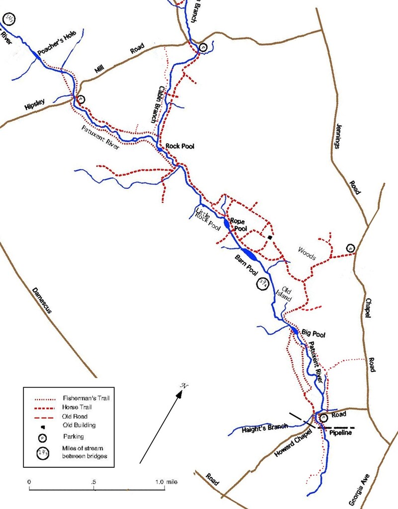
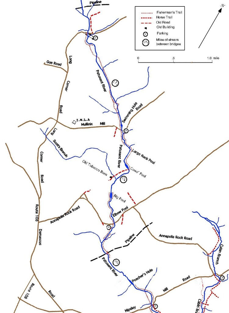
Upper Patuxent River Special Area
In addition to the PDF maps, there are three photos of Upper Patuxent Trail Maps. If you have a smartphone you can upload the Trail Map (UprPaxTrailMap.3.jpg) onto your smartphone, then you will have it with you as you wander around the Upper Patuxent. You can then just call it up and zoom into the area you are hiking and fishing. If you do not have a smartphone or do not carry it with you, there are two smaller maps of portions of the first. One is "3S" from Hipsley Mill to Howard Chapel. The other is labeled version "3N" and covers from Hipsley Mill upstream to Long Corner. You might print them out as 2-sided and slip the sheet in a large ziplock to carry in your vest. Hopefully with the trail maps you will not get lost in the Upper Patuxent!
- PDF map of Upper Patuxent Catch and Release Area
- Trail Map of Upper Patuxent (UprPaxTrailMap.3.jpg)
- Trail Map of Hipsley Mill to Howard Chapel (UprPaxTrailMap.3S.jpg)
- Trail Map of Hipsley Mill upstream to Long Corner (UprPaxTrailMap.3N.jpg)
- Real-Time Stream Data: Patuxent River @ Rt 97
Patuxent River below Brighton Dam (Flies Only)
- Satellite View of Catch and Release Area
- PDF map of Catch and Release Area
- 2025 Water Quality Measurements Below Brighton Dam
- Real Time Stream Data: Patuxent River below Brighton Dam
Middle Patuxent River (Delayed Harvest)
- Real-Time Stream Data Unavailable
Little/Middle Patuxent River at Savage, MD
- Real-time Stream Data: Little Patuxent River at Savage, MD
Paint Branch
- Real-Time Stream Data Unavailable
Northwest Branch
- Real-Time Stream Data Unavailable
Patapsco River
- Real-Time Stream Data Unavailable (Gage sta. closed 2004)
South Branch Patapsco River (Delayed Harvest)
- Real-Time Stream Data Unavailable
Morgan Run
- Real-Time Stream Data Morgan Run at London Bridge Road
Gunpowder River
- PDF Trail Map of Gunpowder Falls State Park
- Real-Time Stream Data: Gunpowder Falls @ Falls Rd below Prettyboy Dam
- Gunpowder Falls below Monkton, MD
- Current Conditions on Gunpowder, courtesy Backwater Angler
Big Hunting Creek
- Real-Time Stream Data (temperature only): Big Hunting Creek
- Fly Fisherman's Guide to Big Hunting Creek
Catoctin/Little Catoctin Creek within Doubs Meadow Park (Delayed Harvest)
- Real-Time Stream Data Catoctin Creek near Middletown
Catoctin Creek within Catoctin Creek Park (Delayed Harvest)
- Real-Time Stream Data Catoctin Creek near Middletown
Beaver Creek
- Real-Time Stream Data Unavailable
Town Creek
- Real-Time Stream Data: Town Creek near Oldtown, MD
Savage River
- Real-Time Stream Data: Savage R. below Savage dam (incl. temp.)
- Savage Dam-Pool, inflow, outflow
- upper Savage flows
- Stream report, courtesy Savage River Outfitters
North Branch Potomac
North Branch Potomac - Barnum-Westernport
- Real-Time Stream Data: N Branch @ Barnum, WV (incl. temp.)
- JR Dam-Pool, inflow, outflow.
North Branch Potomac - Westernport-Keyser
- Real-Time Stream Data: Luke, MD (below confluence of N Branch & Savage, incl. temp.)
- N Branch @ Pinto, MD (incl. temp.)
North Branch Potomac - Keyser-Black Oak
- Real-Time Stream Data: Luke, MD (below confluence of N Branch & Savage, incl. temp.)
North Branch Potomac - Black Oak-Pinto
- Real-Time Stream Data: N Branch @ Pinto, MD (incl. temp.)
Casselman River
- Real-Time Stream Data: Casselman R at Grantsville, MD
Youghiogheny (Yough) River Special Area
- Real-Time Stream Data: Yough at Friendsville, MD